Question 1 of 10
The Amazon Basin of South America contains the world's largest tropical rainforest, covering roughly 5.5 million square kilometers. The characteristic vegetation of this biome — tall broad-leaved evergreen trees forming a multi-layered canopy — is MOST directly the result of which combination of physical factors? 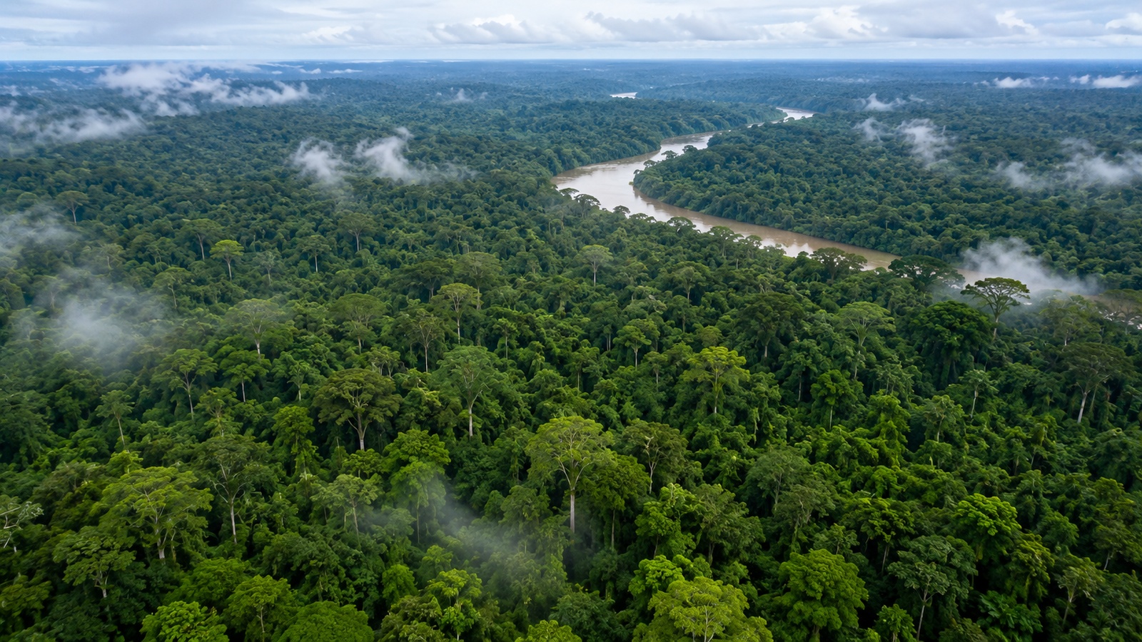
AA permanent absence of any precipitation, similar to major world deserts.
BVery cold temperatures for most of the year and low annual precipitation.
CRegular winter snow accumulation followed by spring melt.
DConsistent year-round warm temperatures combined with abundant year-round rainfall.
Explanation
Tropical rainforest biomes require both consistently warm temperatures (little seasonal variation) AND high year-round precipitation. Broad-leaved evergreen trees form multi-story canopies where those two conditions coincide, as in the Amazon Basin. Options B, C, D describe conditions that would produce entirely different biomes (tundra, temperate, desert).
Question 2 of 10
Which of the following BEST describes a continent?
AA body of freshwater found in a mountainous region.
BA moving band of clouds in the upper atmosphere.
CA small island typically surrounded by an ocean on all sides.
DA very large landmass, of which Earth has seven traditionally-named examples (Africa, Antarctica, Asia, Australia, Europe, North America, South America).
Explanation
A continent is a very large landmass. Seven continents are traditionally named: Africa, Antarctica, Asia, Australia, Europe, North America, and South America. Options B–D describe features other than continents.
Question 3 of 10
The neolithic revolution (roughly 10,000 BCE onward) — the transition from foraging to settled agriculture — first occurred in several independent centers, including the Fertile Crescent of Southwest Asia, the Yellow and Yangtze River basins of China, and Mesoamerica. From a historical-geographic perspective, this transition MOST directly enabled:
ADenser and more permanent settlement, larger populations, the emergence of cities, and specialized non-farming occupations.
BThe disappearance of all forms of human settlement globally.
CAn immediate universal decline of population everywhere on Earth.
DThe rejection of all agricultural knowledge in every region where it first appeared.
Explanation
The neolithic transition to settled agriculture supported denser and more permanent settlement, larger populations, and the emergence of cities and specialized non-farming occupations (artisans, priests, administrators). This is a foundational concept in the historical geography of human civilization. Options B, C, D contradict documented archaeological history.
Question 4 of 10
The ancient civilizations of Egypt, Mesopotamia, the Indus Valley, and the Yellow River basin share which physical-geographic feature? 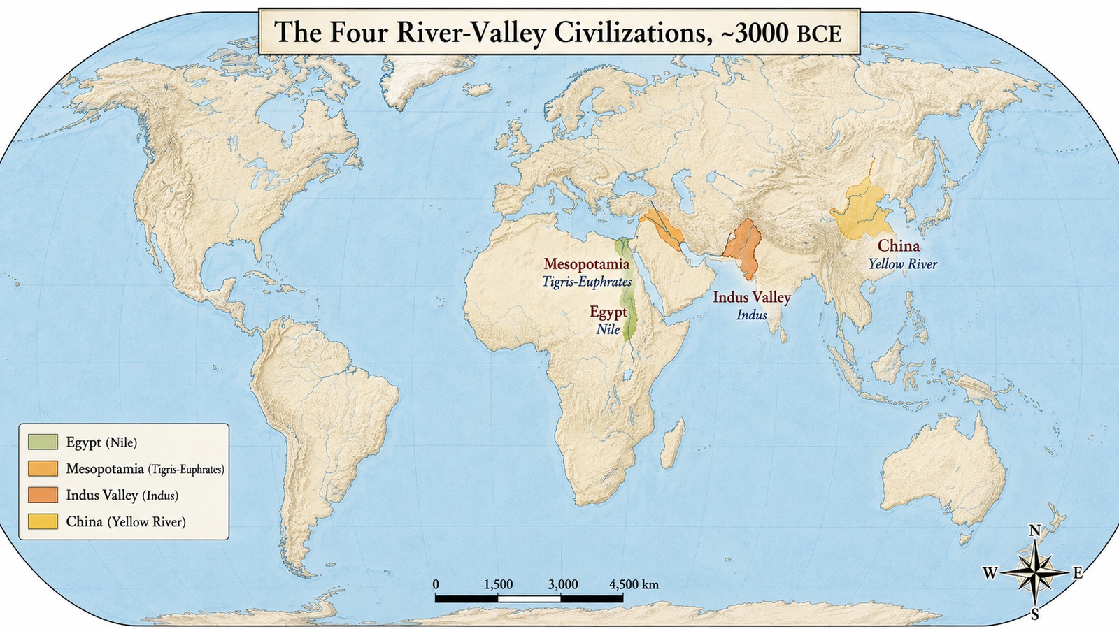
AAll arose in large river valleys with fertile alluvial soils and reliable water supply.
BAll arose in polar tundra environments.
CAll arose on high-altitude mountaintops.
DAll arose in the middle of hot deserts with no surface water.
Explanation
The world's early river-valley civilizations — Egypt (Nile), Mesopotamia (Tigris–Euphrates), Indus Valley (Indus), and the Yellow River basin — all arose in fertile alluvial river valleys that provided reliable water and rich soil for intensive agriculture, in turn supporting dense settlement and complex civilization.
Question 5 of 10
The population pyramid shown represents a country with a wide base, a narrowing middle, and a very small top. Which of the following BEST describes this country's demographic profile?
AVery low fertility with very long life expectancy across all age groups.
BAn evenly distributed population with no bulge or narrowing at any age.
CA population made up entirely of one narrow age band.
DHigh fertility with elevated mortality at older ages — typical of low-income countries earlier in the demographic transition.
Explanation
A wide base means large recent birth cohorts (high fertility). A very small top means few people survive into older ages (elevated older-age mortality and/or long time since previous large cohorts). This pyramid shape is characteristic of low-income countries earlier in the demographic transition. Options B–D describe shapes that do not match.
Question 6 of 10
The map shown displays the world's major climate zones (Köppen classification) with tropical, arid, temperate, continental, and polar bands shown in different colors. Which pattern MOST clearly emerges from this map? 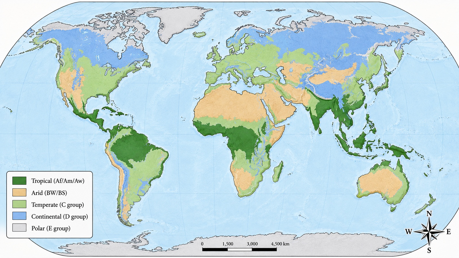
AClimate zones are largely arranged in latitudinal bands, modified by proximity to oceans, elevation, and prevailing winds.
BClimate zones are arranged in longitudinal (north–south) bands rather than latitudinal bands.
CThe entire world falls into a single climate zone.
DClimate zones are randomly distributed with no relationship to latitude, oceans, elevation, or winds.
Explanation
World climate zones are LARGELY ARRANGED IN LATITUDINAL BANDS — tropical near the equator, arid at ~30° north and south, temperate at middle latitudes, continental in high middle latitudes, polar at high latitudes. This banding is MODIFIED by proximity to oceans, elevation, and prevailing winds. Options B–D contradict this well-established pattern.
Question 7 of 10
The concept of SOVEREIGNTY refers to which of the following?
AA state's supreme authority over its own territory and population, and its independence from external control by other states.
BA state's requirement to accept all rulings from every other state.
CA state's ban on maintaining any government.
DA state's absence of any borders.
Explanation
SOVEREIGNTY refers to a state's supreme authority over its own territory and population, and its independence from external control by other states. The Westphalian system of international relations (from the 1648 Peace of Westphalia) formalized this concept in modern Europe, and it remains a foundational principle of international law.
Question 8 of 10
Lines of latitude on a world map do WHICH of the following?
ARun east–west (parallel to the equator) and measure north–south position on Earth's surface.
BDo not exist on any standard world map.
CVary randomly with no consistent orientation.
DRun north–south (meridians) and measure east–west position.
Explanation
Lines of latitude are drawn east–west (parallel to the equator) and are used to measure a location's north–south position. North–south lines (meridians) measure east–west position and are called lines of longitude.
Question 9 of 10
The climograph shown displays monthly average temperature (line) and monthly precipitation (bars) for a coastal city in the middle latitudes. Temperatures are mild year-round (winter around 5°C, summer around 20°C), and precipitation is heaviest in winter months and lightest in summer months. Which climate type does this pattern MOST closely match?
AContinental interior climate with hot summers and very cold winters.
BPolar tundra climate with year-round subfreezing temperatures.
CMediterranean climate — mild wet winters and dry summers, typical of west coasts around 30–40° latitude.
DTropical rainforest climate with uniform hot temperatures and heavy year-round rainfall.
Explanation
MEDITERRANEAN CLIMATE is characterized by mild wet winters and dry summers, occurring on west coasts around 30–40° latitude in both hemispheres (California, central Chile, southwestern Cape of Africa, southern Australia, and around the Mediterranean Sea). The described climograph pattern is diagnostic of this climate type. Options B, C, D describe other Köppen climate types.
Question 10 of 10
China's BELT AND ROAD INITIATIVE (BRI), launched in 2013, is BEST characterized as:
AA program that never actually launched.
BA private commercial fund with no state involvement.
CA large-scale program of Chinese investment in transportation, energy, and other infrastructure across dozens of partner countries in Asia, Africa, Europe, and Latin America — with substantial economic and geopolitical implications.
DA single railway project connecting two adjacent cities.
Explanation
China's BELT AND ROAD INITIATIVE is a large-scale program of Chinese investment in transportation (rail, road, port), energy, and other infrastructure across dozens of partner countries. It has substantial economic dimensions (financing terms, procurement patterns, employment effects) and geopolitical dimensions (long-term strategic positioning, debt sustainability of partner countries, alternative development-finance offerings). It is one of the most-analyzed geographic initiatives of the 21st century.